Time Travel
Mesozoic Paleogeography
Drag the slider to travel through time from 245 to 66 million years ago and see how the continents moved.


Mollweide Paleographic Maps — Wikimédia Commons, CC BY-SA 4.0
252–201 Ma Jurassic
201–145 Ma Cretáceous
145–66 Ma
Continental Configuration
Mollweide Paleographic Map of Earth, 250 Ma (Olenekian Age) — Wikimedia Commons, CC BY-SA 4.0
Environments & Fauna
Early Triassic ~245 Ma
About 245 million years ago, Earth was still recovering from the greatest mass extinction in its history: the Permian-Triassic extinction event, which eliminated approximately 96% of marine species and 70% of terrestrial ones. All continents were joined in a single supercontinent called Pangaea, surrounded by the global ocean Panthalassa. The climate was extremely hot and arid across the continental interior, with brutal seasonal swings. Polar zones were entirely ice-free. South America and Africa formed the southern portion of Pangaea, known as Gondwana, still fused together, covered by reddish arid soils and sparse primitive conifer forests. Antarctica occupied more temperate latitudes than today, with no ice cap. Europe and North America formed the northern block, Laurasia, separated only by shallow inland seas. Asia was fragmented into smaller terranes still colliding. Sea levels were high, flooding vast coastal areas. Vegetation was dominated by lycopsids, ferns, and primitive conifers that had survived the extinction. The first archosaurs and temnospondyls were recolonizing devastated continents, setting the stage for the rise of dinosaurs in the geologic decades to come.
Environment Reconstruction
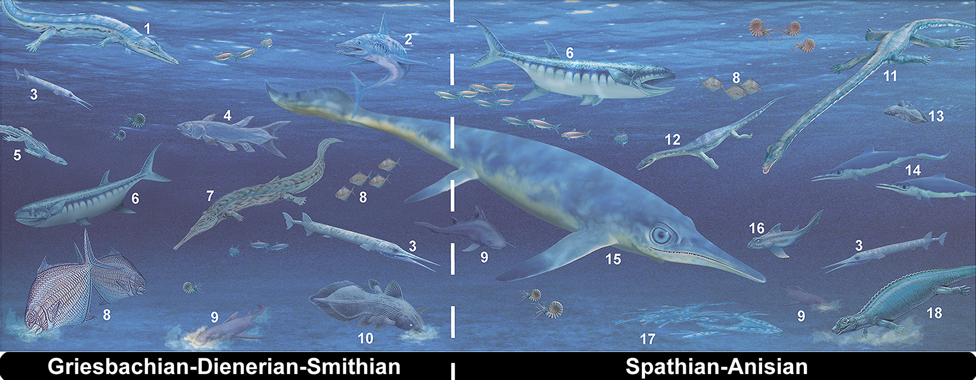
Early Triassic marine apex predators illustrating biotic recovery following the Permian-Triassic extinction event.
Nadine Bösch and Beat Scheffold (2013), CC BY 2.5
Continental Configuration
Mollweide Paleographic Map of Earth, 240 Ma (Ladinian Age) — Wikimedia Commons, CC BY-SA 4.0
Environments & Fauna
Middle Triassic ~230 Ma
About 230 million years ago, Pangaea remained joined but early tectonic stress already hinted at future breakup. The climate had moderated somewhat compared to the Early Triassic, yet the continental interior was still dominated by arid deserts and seasonal rivers. South America, particularly modern-day Argentina, hosted critical ecosystems documented by the Ischigualasto Formation, where the first confirmed dinosaurs lived: Eoraptor lunensis and Herrerasaurus ischigualastensis. These were relatively small animals inhabiting seasonally dry alluvial plains. Southern and eastern Africa (then continuous with South America) showed similar landscapes, with rhynchosaurs and cynodonts dominating terrestrial ecosystems. Antarctica occupied more tropical latitudes and supported denser forests. Europe was a tropical archipelago bathed by the Tethys Sea, with primitive coral reefs. North America was dominated by extensive red arid plains. Central and eastern Asia was consolidating as terranes collided with the Siberian core. Sea levels were moderately high, and shallow epicontinental seas covered parts of what are now Europe and North America.
Environment Reconstruction

Ischigualasto Formation fauna (Argentina), cradle of early dinosaurs: Eoraptor, Herrerasaurus and contemporaries, ~230 Ma.
Nobu Tamura, CC BY-SA 4.0
Continental Configuration
Mollweide Paleographic Map of Earth, 220 Ma (Norian Age) — Wikimedia Commons, CC BY-SA 4.0
Environments & Fauna
Late Triassic ~210 Ma
About 210 million years ago, dinosaurs had diversified considerably and colonized all continents of Pangaea. The supercontinent was beginning to show the first rifts that would herald the opening of the North Atlantic in the Early Jurassic. The climate was warm and seasonal, with powerful monsoons affecting broad swaths of Pangaea. South America hosted a growing variety of dinosauriformes, both early saurischians and ornithischians. The African region, especially the basins of modern Morocco and South Africa, recorded similar fauna with prosauropods and primitive carnivores. Antarctica, still in a more equatorial position than today, supported dense forests of conifers and tree ferns. Europe was a mosaic of tropical islands and shallow seas, with endemic fauna on some Tethyan archipelago islands. North America during the Norian-Rhaetian (Chinle and Dockum formations) hosted coelophysids and early herbivores like Plateosaurus relatives. Eastern Asia remained relatively isolated. Volcanism of the Central Atlantic Magmatic Province (CAMP) was about to begin, closing the Triassic with another mass extinction around 201 Ma.
Environment Reconstruction

Middle-Late Triassic landscape of southern Brazil: Prestosuchus chiniquensis and Parvosuchus aurelioi competing over a dicynodont carcass.
Matheus Fernandes / R. T. Müller et al., CC BY 4.0
Continental Configuration
Mollweide Paleographic Map of Earth, 190 Ma (Pliensbachian Age) — Wikimedia Commons, CC BY-SA 4.0
Environments & Fauna
Early Jurassic ~190 Ma
About 190 million years ago, the end-Triassic extinction had eliminated the main competitors of dinosaurs, opening the way for their global dominance. Volcanism of the Central Atlantic Magmatic Province (CAMP) had injected enormous quantities of CO2 into the atmosphere, causing temporary global warming. Pangaea was beginning its fragmentation: an initial rift was separating North America from South America and Africa, forming a narrow interior sea that would eventually become the Central Atlantic. The climate was globally warm and humid, more homogeneous than in the Triassic, without polar ice caps. South America and Africa were still broadly connected, with dinosaurs such as Dracovenator and the earliest sauropods of the Vulcanodon group moving through the region. Antarctica and Australia remained joined in the southern portion of Gondwana, covered by humid forests of conifers and ginkgos. North America was partially flooded by epicontinental seas and supported dense forests of ferns and conifers. Europe was a low-latitude archipelago bathed by warm shallow seas. The dinosaur group was rapidly expanding into all available ecological niches.
Environment Reconstruction

Terrestrial environment of the Early Jurassic (Pliensbachian-Toarcian, ~185 Ma), depicting typical Early Jurassic flora and fauna.
Lucas Attwell, CC BY-SA 3.0
Continental Configuration
Mollweide Paleographic Map of Earth, 170 Ma (Bajocian Age) — Wikimedia Commons, CC BY-SA 4.0
Environments & Fauna
Middle Jurassic ~170 Ma
About 170 million years ago, Gondwana and Laurasia were definitively separating, with the Central Atlantic Ocean expanding rapidly. The proto-Indian Ocean was beginning to open between Africa, Antarctica, and India. The climate was uniformly warm and humid, with dense forests covering latitudes that are deserts today. There was no polar ice. South America remained joined to Africa, but a growing rift along what would become the South Atlantic was already separating dinosaur faunas on the two landmasses. Giant sauropods such as members of the Cetiosauridae family predominated on both continents. Antarctica, then at South Pole latitudes but still unglaciated, supported open forests with a positive mean annual temperature. Asia was oriented in multiple blocks; China in particular hosted a remarkably diverse dinosaur fauna, including the earliest ceratosaurs and ornithopods. Europe consisted of shallow islands in the Tethys Sea, with significant endemism. North America was beginning to separate from Europe across the nascent North Atlantic. Vegetation was dominated by ferns, horsetails, conifers, cycads, and ginkgos, with no flowering plants yet.
Environment Reconstruction

Shaximiao Formation dinosaurs (Middle Jurassic, China): Yangchuanosaurus, Mamenchisaurus, Tuojiangosaurus and Gigantspinosaurus.
ABelov2014, CC BY-SA 3.0
Continental Configuration
Mollweide Paleographic Map of Earth, 155 Ma (Oxfordian Age) — Wikimedia Commons, CC BY-SA 4.0
Environments & Fauna
Late Jurassic ~150 Ma
About 150 million years ago, the Late Jurassic was one of the periods of greatest dinosaur diversity in Earth's history. Gondwana and Laurasia were separated, though occasional land corridors still allowed faunal exchange. The South and Central Atlantic were expanding rapidly. The climate was warm and humid, with high global moisture and a complete absence of polar ice. In North America, the Morrison Formation hosted extraordinary fauna: Allosaurus, Brachiosaurus, Diplodocus, Stegosaurus, and Camarasaurus lived on plains seasonally flooded by meandering rivers. In East Africa, the Tendaguru Formation (modern Tanzania) recorded a parallel and equally gigantic fauna, including Giraffatitan brancai and Kentrosaurus, suggesting a land connection or recent dispersal. South America hosted the earliest titanosaurs and primitive abelisauroids. Europe was a subtropical archipelago with island-dwarfed dinosaurs, a fauna well-documented in Portugal, England, and Germany. Eastern Asia developed its own distinct fauna, with unique sauropods and theropods. Antarctica and Australia remained joined in southern Gondwana, with a cool, humid temperate climate. Conifers, cycads, and ginkgos dominated the landscape, with no flowering plants.
Environment Reconstruction

Late Jurassic: Gargoyleosaurus (Morrison Formation) drinking from a pool, surrounded by horsetails, ferns and conifers.
Conty, CC BY-SA 4.0
Continental Configuration
Mollweide Paleographic Map of Earth, 120 Ma (Aptian Age) — Wikimedia Commons, CC BY-SA 4.0
Environments & Fauna
Early Cretaceous ~130 Ma
About 130 million years ago, the Early Cretaceous witnessed the progressive fragmentation of Gondwana and the rise of radically new ecosystems. The most transformative event was the emergence of angiosperms, the flowering plants, which were beginning to colonize disturbed and humid environments, though still outnumbered by conifers and ferns. The South Atlantic was opening between South America and Africa, although a land connection still existed in the north, allowing faunal exchange. North Africa and southern Europe were bathed by the Tethys Sea. In Europe, the Wealden Group faunas (southern England, northern France, Spain) included Iguanodon, Baryonyx, and Polacanthus. Eastern China, then with a humid subtropical climate, produced exceptional fauna with feathered dinosaurs: Microraptor, Sinornithosaurus, and the earliest true birds within the Enantiornithes group. North America hosted titanosaurs and spinosaurids in its swampy plains. South America and Africa were progressively isolating, allowing the evolution of endemic lineages such as South American abelisaurids and African carcharodontosaurids. Antarctica and Australia remained connected in southern Gondwana.
Environment Reconstruction
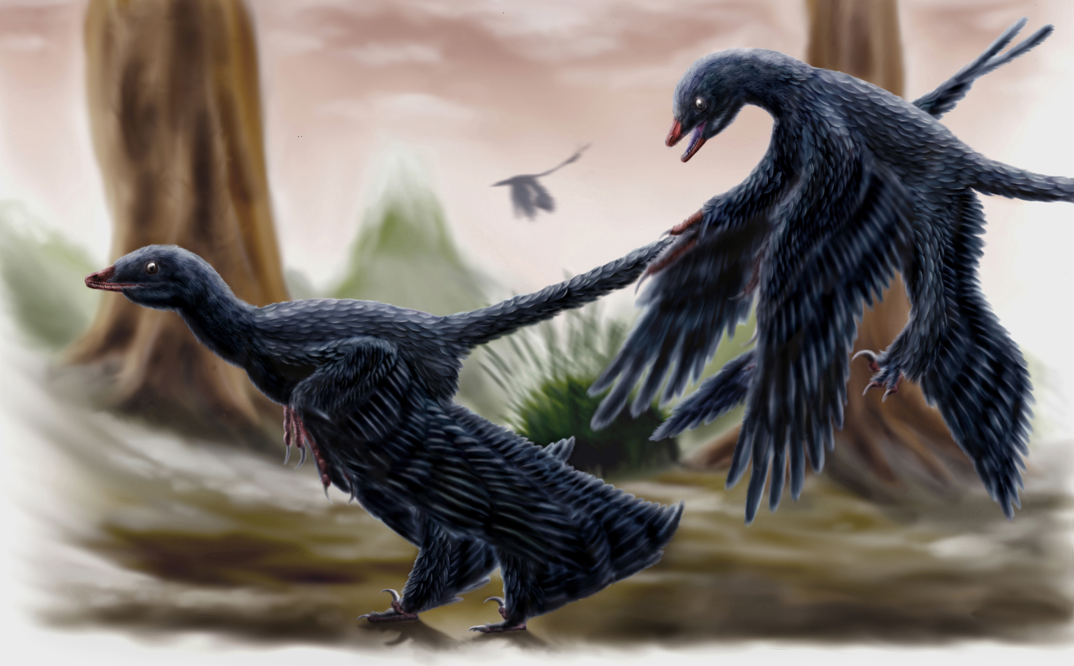
A pair of Microraptor in the Yixian Formation forest (Early Cretaceous, Liaoning, China, ~125 Ma), representing the feathered-dinosaur-rich Jehol Biota.
Durbed, CC BY-SA 3.0
Continental Configuration
Mollweide Paleographic Map of Earth, 105 Ma (Albian Age) — Wikimedia Commons, CC BY-SA 4.0
Environments & Fauna
Mid-Cretaceous ~100 Ma
About 100 million years ago, the Mid-Cretaceous was the peak of a global greenhouse unprecedented in the past 250 million years. Mean temperatures were 8 to 10 degrees Celsius above current levels, the poles were temperate arctic zones without permanent ice, and sea levels stood 100 to 200 meters above today's, flooding vast continental regions. In North America, the Western Interior Seaway split the continent in half, creating two subcontinents: Laramidia to the west and Appalachia to the east. In South America, the newly formed South Atlantic was still narrow and shallow, but already isolating fauna, fueling the explosion of gigantic titanosaurs like Argentinosaurus and carcharodontosaurids like Giganotosaurus. Africa hosted diverse fauna with spinosaurids (Spinosaurus) and abelisaurids in its tropical deltas. Europe was a subtropical archipelago. India was in rapid northward drift, a large isolated island. Eastern Asia developed its own fauna with primitive tyrannosaurs and ornithopods. Antarctica was separated from Australia and experienced a warm temperate climate without glaciation. Angiosperms were expanding globally, rapidly diversifying terrestrial ecosystems with new plant forms.
Environment Reconstruction

Bahariya Formation paleoecosystem (Cenomanian, Egypt): Spinosaurus aegyptiacus with a lungfish in its jaws and abelisaurid in the foreground.
Andrew McAfee, CC BY 4.0
Continental Configuration
Late Cretaceous paleogeographic map — Wikimedia Commons, public domain.
Environments & Fauna
Late Cretaceous ~70 Ma
About 70 million years ago, the last non-avian dinosaurs were living in a world of continents progressively more similar to those of today, though still arranged differently. The Western Interior Seaway still divided North America into Laramidia and Appalachia, hosting distinct faunas: Laramidia had Tyrannosaurus rex, Triceratops, Edmontosaurus, and Ankylosaurus; Appalachia had insular hadrosaurids and nodosaurids. South America was almost completely isolated, with titanosaurs like Dreadnoughtus and abelisaurids like Carnotaurus ruling the continent. Africa hosted its own titanosaurs and abelisaurids, with increasing influence from Asian fauna via occasional land bridges. India continued its northward drift, with endemic fauna such as Rajasaurus. Central and eastern Asia was the diversification center for tyrannosaurs, oviraptorids, and dromaeosaurids. Europe was an archipelago with dwarf dinosaurs like Magyarosaurus. Antarctica experienced temperate summers with beech tree and conifer forests. The global climate was gradually cooling. At 66 Ma, the Chicxulub asteroid impact in Mexico would extinguish all non-avian dinosaurs, ending 165 million years of dominance.
Environment Reconstruction

Hell Creek Formation fauna (Maastrichtian, ~66 Ma): Ankylosaurus, Tyrannosaurus, Quetzalcoatlus, Triceratops, Struthiomimus and Pachycephalosaurus.
Durbed, CC BY-SA 3.0